WWW.KARLSWALKS.CO.UK
PICTURES AND TRIP REPORTS FROM MY WALKS IN THE ENGLISH LAKE DISTRICT
I drew the short straw In the family car pool lottery so I
was back on the train which I don't mind but It does mean that unless I want to
spend all day travelling I have to start my walk from Windermere, or at least
from the south Lakes. After a busy few weeks dealing wIth my late fathers
affairs I felt the need for a long walk so I made use of the ancient tracks and
pack horse routes and headed for the lovely Longsleddle valley and would see
where I end up. The weather forecast was not good so I was surprised
by the lovely sunshine as I set of from home. This didn’t last though
and as we pulled Into Windermere the heavens opened with that special kind of
Lakeland rain that you know is going to be around all day.
Waterproofs on I set of and soon climbed over Orrest head
and on to the road to Moor How. Climbing up the Garburn road I met my first
walkers coming back down the path, the rain was still hammering down and as I
have found before the worse the weather the more cheerful people seem to be.
Everyone I met exclaimed that It was a lovely morning and there was plenty of
banter about the hosepipe ban which had just come Into force. Might be that Its
a British trait and maybe the
weather keeps away the casual stroller
who more often than not won't make eye contact, nevermind say hello
Over the tops I went and started the descent Into Kentmere,
the car park by the church was full even on a day like today and I was passed by
several drivers manoeuvring round the tiny roads looking for a parking spot.
After a short but steep pull through Green Quarter I joined the Bridleway and
dropped down Into Sadgill where I had a bite to eat sheltering In the farm wood
store. The river Sprint was about twice as wide as I remembered It and the
waterfalls were quite Impressive as were the streams that ran down the fell and
across the path. Crossing became harder as they were getting wider and deeper as
I progressed up the valley.
I started to
think about where I was going to camp, by now I had quite a strong wind to
contend with as well as the rain so my first thought of a high camp on Branstree
or Selside was dismissed and I decided to head for the shelter of Mardale even
though thIs would mean my route back tomorrow would start with a stiff climb.
Once over the Gatescarth pass I headed for the Rigg, a wooded area on a
promontory jutting out Into Haweswater. I had seen the "no camping"
signs and as I reached the Rigg I saw the reason for these. The ground was
littered with empty cans and scarred by the remains of open fires, there was
even an abandoned shelter flapping from a tree. The relative accessibility to
the road must attract the chavs who as usual care for only themselves and have
no thought for the damage they do. Not wanting to be moved on by a keen-eyed
ranger I headed deeper Into the woods and found a space behind a wall just big
enough for the Lasercomp. My waterproofs had given up the ghost long before so I
had to change my soakIng clothes but was soon warm In my sleeping bag and
cooking my tea
After a surprisingly still night apart from the constant
patter of the rain. The morning brought even more rain and as left the shelter
of the wood the wind became ferocious I headed up to Blea water as I had never
visited It before and also I could join the Long Stile ridge higher up.
Thankfully the wind had slackened off and I climbed up to High Street without
Incident. After visiting Thornthwaite crag and beacon I found the top of Park
Rake and made my descent Into the valley. As I passed Troutbeck Tongue I decided
to keep on the path on the west of the valley which I later regretted as there
was a bit to much road walking but I eventually left the road at Fusethwaite
Yeat and crossed the fields back to Orrest Head and Windermere where as I sat
waiting for the train the sun came out!
No pictures this time as I kept my camera buried in my bag as I have never walked in such heavy rain that lasted so long and I hardly had a view to speak of. Of course I now wish I had risked a few shots but I will just have to do the walk again in better weather.
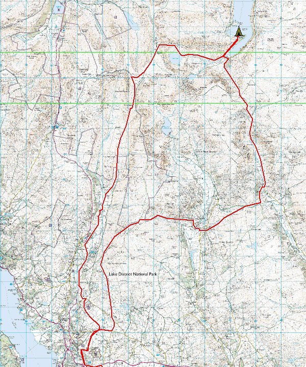
The route. About 25 miles in total with around 3500ft of ascent.